
 By
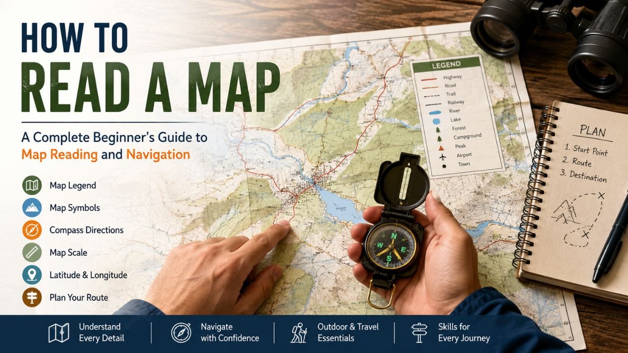
By Knowing how to read a map is a practical skill that can help you navigate unfamiliar places, understand landscapes, plan journeys, and become more confident when traveling without relying entirely on digital navigation. Although smartphones and GPS applications have made navigation easier, traditional maps still provide valuable information about an area that may not always be obvious on a small screen.
For beginners, how to read a map may initially seem complicated because maps contain symbols, lines, colors, numbers, directions, and scales. However, once you understand the basic components, map reading becomes much easier. Whether you are studying geography, planning a hiking trip, traveling through a new region, or simply developing better navigation skills, learning the fundamentals can make maps much more useful.
This guide explains how to read a map step by step, including map symbols, the map legend, scale, compass directions, coordinates, physical features, and practical navigation techniques.
What Is a Map?
A map is a visual representation of a geographic area. It reduces a large real-world space into a smaller format while using symbols, colors, lines, and labels to communicate information.
Maps can represent cities, countries, roads, mountains, rivers, trails, political boundaries, buildings, or entire continents. Different maps are designed for different purposes. A road map helps drivers identify routes, while a topographic map provides detailed information about elevation and terrain.
Understanding how to read a map starts with identifying what type of map you are using and what information it is designed to show.
Common types include:
- Road maps
- Political maps
- Physical maps
- Topographic maps
- Weather maps
- Tourist maps
- Trail and hiking maps
- Street maps
- Nautical maps
Before interpreting the details, look at the map as a whole. Identify the area covered, title, orientation, scale, and legend. This gives you context before you begin looking for a particular location.
Read more: White Dots on Monitor | Dell Display Problem | Green Dots on Laptop Screen | Artifacting on Screen
How Do We Read a Map?
If you are wondering how do we read a map, start by understanding its basic components rather than trying to interpret everything at once.
First, identify the map’s title and geographic area. Next, locate the map legend, which explains the symbols and colors used. Then check the north arrow or compass to understand orientation. After that, examine the map scale to determine the relationship between distances on the map and actual distances on the ground.
Once these elements are clear, find your current location or starting point. From there, identify your destination and examine roads, trails, rivers, landmarks, and other features connecting the two locations. How to Read a Map effectively requires identifying your starting point and destination before choosing a route.
A simple approach is:
- Identify the map and its purpose.
- Find north.
- Read the map legend.
- Understand the scale.
- Locate your starting point.
- Find your destination.
- Identify possible routes.
- Check distances and physical obstacles.
- Follow the route using recognizable landmarks.
This process forms the foundation of effective map reading.
Understand the Map Legend
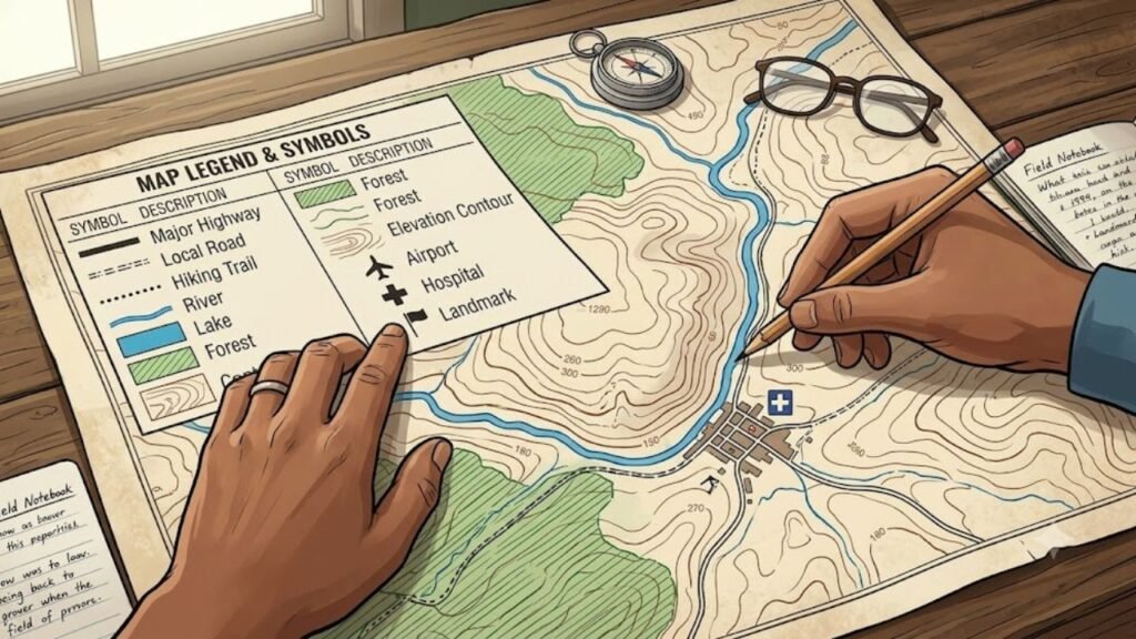
One of the first things to examine when learning how to read a map is the map legend. The legend, sometimes called the key, explains what different symbols, lines, patterns, and colors represent.
For example, a map may use different lines for highways, local roads, hiking trails, railways, or administrative boundaries. A blue line may represent a river, while a blue area may indicate a lake. How to Read a Map correctly starts with understanding what its symbols and visual elements mean.
The map key serves the same basic purpose. It translates the visual language of the map into information you can understand.
Some common examples include:
- Blue lines for rivers or streams
- Blue areas for lakes and other water bodies
- Green areas for forests or vegetation
- Brown lines on topographic maps for elevation
- Black or gray lines for roads and boundaries
- Special symbols for airports, hospitals, schools, or landmarks
Never assume that a symbol means something based only on its appearance. Different maps may use different conventions. Always check the map legend before interpreting unfamiliar symbols.
Learn Map Symbols
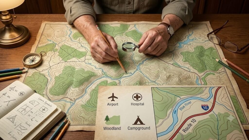
Map symbols allow a map to communicate large amounts of information without writing everything in words. Learning common symbols can make navigation faster and easier.
A small airplane symbol might identify an airport, while a cross or medical symbol could identify a healthcare facility. A tree or shaded green area may indicate woodland. A tent symbol can identify a campground on some recreational maps. Learning the legend is an important step in How to Read a Map accurately.
When learning how to understand a map, pay attention to both symbols and labels. A symbol tells you what type of feature exists, while the label usually identifies its name.
For example, a river may appear as a blue line, but its written name tells you which river it is. Similarly, a road symbol can show the presence of a road, while the road’s label helps you determine where it leads.
The more familiar you become with map symbols, the faster you can interpret a map without constantly referring to the legend.
Understand the Map Scale
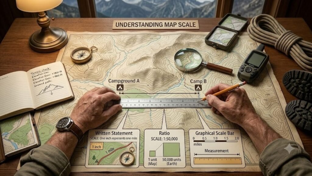
The map scale tells you how distances shown on the map relate to actual distances on Earth. Understanding distance is another essential part of How to Read a Map.
For example, a scale might state that one inch represents one mile. This means that a one-inch measurement on the map corresponds to one mile in the real world.
A map may show scale in several ways:
- A written statement
- A ratio
- A graphical scale bar
A ratio such as 1:50,000 means that one unit on the map represents 50,000 of the same units on the ground.
The scale is particularly important when planning a trip. Two locations may appear close together on a map but could actually be several miles apart.
Understanding how to read a map therefore requires more than identifying locations. You also need to understand how far those locations are from one another.
For hiking and outdoor navigation, scale can be especially important because terrain, elevation, and route conditions may make the actual journey longer than the straight-line distance.
Learn Compass Directions
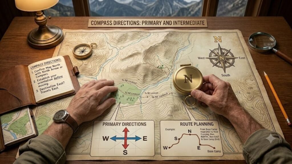
Understanding compass directions is another fundamental part of map reading. Most maps are oriented so that north is at the top, but you should confirm this using the north arrow or compass indicator.
The four primary directions are:
There are also intermediate directions such as northeast, southeast, southwest, and northwest.
When learning how to read a map, always establish your orientation before following a route. If you know that your destination is east of your current location, you can use that information to understand the general direction of travel.
A map can also be rotated to match the landscape around you. This technique can make it easier to compare visible landmarks with features represented on the map.
How to Use a Compass With a Map
Learning how to use a compass can make traditional navigation much more reliable. A compass points toward magnetic north, allowing you to determine direction even when there are few visible landmarks.
To use a compass with a map:
- Place the map on a flat surface.
- Identify the map’s north direction.
- Place the compass on the map.
- Align the compass and map according to the appropriate orientation.
- Determine your direction of travel.
- Follow the selected bearing while checking your surroundings.
When learning how to read a map, remember that magnetic north and geographic north are not exactly the same. The difference, known as magnetic declination, can matter when precise navigation is required.
For casual city navigation, this distinction may be less important. For hiking, wilderness travel, or professional navigation, it can become significant.
Understand Directions on a Map
Directions on a map describe how locations relate to one another. You may see a destination described as north of a river, west of a highway, or southeast of a town.
To interpret these relationships, first establish north. Then compare the location of different features. How to Read a Map for outdoor travel also requires paying attention to terrain and distance.
For example, if a campground is north of a lake and a trail runs east from the campground, you can use those relationships to understand the route even if you do not know every trail name.
This is one reason map reading remains useful even when traveling in unfamiliar areas. You can understand geographic relationships instead of simply following a series of automated instructions.
How to Find Your Location on a Map
One of the most important steps in how to read a map is finding where you are.
If you are using a city map, recognizable landmarks can help. Look for:
- Major roads
- Bridges
- Rivers
- Railway lines
- Public buildings
- Parks
- Intersections
- Distinctive geographic features
If you are hiking, compare visible mountains, valleys, streams, trails, and other landmarks with the features shown on your map. How to Read a Map becomes more practical when you can accurately identify your current position.
Once you identify your approximate position, mark it mentally or physically. From there, determine the direction and distance to your destination.
Avoid moving immediately after identifying only one landmark. Confirm your location using multiple features whenever possible. This reduces the risk of navigating from an incorrect position.
Understanding Latitude and Longitude
Latitude and longitude provide a coordinate system for identifying locations around the world.
Latitude measures position north or south of the Equator. Longitude measures position east or west of the Prime Meridian.
Together, these coordinates can identify a specific geographic location. Confirming your position is a key part of How to Read a Map confidently.
Latitude lines run generally east to west, while longitude lines run from north to south. Their intersections create a global coordinate grid.
When learning how to understand a map, coordinates are particularly useful for maps covering large geographic areas. They are also important for GPS devices, aviation, marine navigation, geography, surveying, and outdoor activities.
A location might be represented using degrees, minutes, and seconds or decimal degrees. Learning to recognize the coordinate format used by your map can prevent confusion.
How Do I Read a Topographic Map?
A common question is how do I read a topographic map, particularly among hikers, campers, students, and outdoor enthusiasts. Coordinates provide another useful tool when learning How to Read a Map.
Topographic maps show the shape and elevation of land. One of their most important features is the contour line.
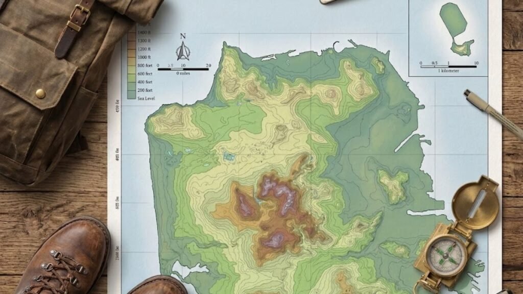
Contour lines connect points that have the same elevation. When contour lines are close together, the terrain is generally steeper. When they are farther apart, the slope is generally gentler.
Topographic maps may also show:
- Mountains
- Valleys
- Ridges
- Streams
- Roads
- Trails
- Buildings
- Forests
- Elevation points
If you are trying to determine whether a hiking route is easy or difficult, studying contour lines can provide important information before you begin.
For anyone asking how to read a map for outdoor navigation, understanding contour lines is an essential skill.
How to Read a Physical Map
Learning how to read a map on paper is still valuable because physical maps do not depend on batteries, mobile signals, or internet connectivity.
When reading a physical map, keep it oriented correctly and frequently compare the map with your surroundings.
A useful technique is to identify three or more recognizable features. For example, you might identify a road intersection, a river, and a hill. If all three correspond to the map, you can be more confident about your position.
Paper maps can also provide a broader view than a smartphone screen. This allows you to see alternative routes, surrounding geographic features, and the overall layout of an area.
How to Plan a Route Using a Map
Once you know how to read a map, you can use that knowledge to plan a route. How to Read a Map on paper also helps you understand the wider area around your route.
Start by identifying your starting point and destination. Then examine the available roads, trails, or paths between them.
Do not automatically select the shortest route. Consider:
- Distance
- Terrain
- Elevation
- Road conditions
- Rivers or other obstacles
- Restricted areas
- Weather conditions
- Available landmarks
- Alternative routes
For outdoor travel, a route that looks short may take significantly longer because of steep terrain or difficult surfaces.
Good navigation skills involve understanding both the map and the environment rather than simply following a line between two points.
Common Map-Reading Mistakes
Beginners often make a few predictable mistakes.
- Ignoring the Legend: A person may assume they understand symbols without checking the map key. This can lead to incorrect interpretations.
- Forgetting the Scale: A map can make two places appear close together even when they are several miles apart. Always check the scale.
- Losing Orientation: If you turn around while traveling, it is easy to become confused about directions. Recheck north and your surroundings regularly.
- Relying on One Landmark: One landmark may appear similar to another. Confirm your location using several features.
- Ignoring Terrain: A straight route may not be practical. Mountains, rivers, cliffs, and restricted areas can change the best path.
- Not Checking the Map Regularly: Waiting until you are completely lost makes navigation harder. Check your position periodically.
Tips for Better Map Reading
If you want to improve how to read a map, practice is more valuable than memorizing every symbol.
Start with a familiar neighborhood. Find your home, nearby roads, parks, and major landmarks. Estimate distances using the scale and identify the direction of different locations. Avoiding these mistakes can make How to Read a Map easier and more reliable.
Next, try using a paper map without immediately checking your phone. Practice identifying your location and planning a route.
For outdoor activities, gradually learn more advanced techniques such as contour interpretation, coordinate systems, bearings, and compass navigation.
You can also practice how to read a map by comparing a physical map with a digital map of the same area. This helps you understand how roads, landmarks, boundaries, and geographic features are represented differently.
Why Map Reading Still Matters
Digital navigation has transformed travel, but traditional map-reading skills remain valuable. Technology can fail because of dead batteries, poor connectivity, inaccurate location signals, damaged devices, or unavailable map data.
Knowing how to read a map gives you an independent navigation skill that does not rely entirely on technology.
Map reading also improves spatial awareness. Instead of simply being told to turn left or right, you begin to understand where you are, where you are going, and how different places connect. Regular practice is one of the best ways to improve How to Read a Map skills.
For students, travelers, hikers, emergency responders, and outdoor enthusiasts, these skills can be especially useful.
Read more about: Perplexity Comet | What is Manus AI? | EU AI Act 2026 | Context7 AI |Browser Use AI | Why Is My Computer Screen Red Tinted?
Final Thoughts
Learning how to read a map is much easier when you approach the process systematically. Start with the title, orientation, legend, symbols, and scale. Then learn to identify your position, understand directions, calculate distances, and interpret geographic features.
As your confidence grows, you can develop advanced navigation skills by learning coordinates, contour lines, bearings, and compass use. Whether you are traveling through a city, studying geography, planning a hiking adventure, or preparing for situations where digital navigation may not be available, effective map reading remains a practical and valuable skill.
The key is consistent practice. The more maps you examine and compare with the real world, the easier it becomes to understand their visual language and make confident navigation decisions.
Frequently Asked Questions
Q1: How can I read a map without GPS?
You can read a map without GPS by using the map legend, compass directions, scale, landmarks, roads, and your current location to plan a route.
Q2: How do you know which way is north on a map?
Check the north arrow or compass symbol on the map. On most standard maps, north is shown at the top.
Q3: What do different colors on a map mean?
Map colors can represent different features, such as water, forests, roads, elevation, or boundaries. Always check the map legend for the exact meaning.
Q4: How can I calculate distance on a map?
Use the map’s scale or scale bar to compare the distance measured on the map with the actual distance on the ground.
Q5: Can I learn map reading without a compass?
Yes. Basic map reading can be learned using landmarks, directions, roads, symbols, and scale. A compass is more useful for precise outdoor navigation.
Q6: What is the easiest way to learn map reading?
Start with a familiar area. Practice finding landmarks, identifying directions, reading the legend, measuring distances, and planning simple routes.
Q7: Why are contour lines important on a map?
Contour lines show changes in elevation. Lines that are close together usually indicate steep terrain, while widely spaced lines indicate gentler slopes.
Q8: Is map reading still useful when we have Google Maps?
Yes. Map-reading skills can help when GPS signals, mobile internet, batteries, or digital devices are unavailable. They also improve your understanding of distances and surroundings.